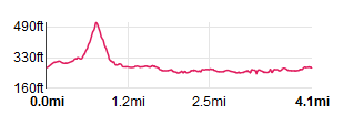
|
From the Market Place, walk to the left of the Moot Hall (pictured above, on a sunnier day than the day we took most of the
photographs to illustrate this route).
Continue to the left of Greggs and the Keswickian Chip Shop to walk along St John's Street (the road becomes Ambleside Road).
|
|
|

|
About 200 metres after leaving the Market Place, turn right along Springs Road.
|

|
Look out for the finger post on the right - follow the narrow path indicated towards Castlehead Wood.
Enter the Wood through a wooden kissing gate.
|

|
Once in the wood, it's not that easy to see the paths due to the fallen leaves (this doesn't just apply in autumn). At the first junction of paths, bear right, to head west.
The path gradually turns towards the south and …
|

|
… about 200 metres after entering the Wood, look out for this marker post on the left. Follow the direction indicated …
|

|
… to climb up the the top of Castlehead - the last few metres are a bit of a scramble …
|

|
… but the view is worth it - even on a dull day!
Return to the main path through the Wood and head almost due west.
|

|
Leave the Wood and cross Borrowdale road to join the path opposite.
|

|
The path leads south, running parallel to Borrowdale Road. If you want a short cut back to Keswick, take the first path on the right -
otherwise continue along the narrow path. You cross a farm road (rurn right for another short cut back to Keswick) and the path winds …
|

|
… through woodland …
|

|
… before bringing you down to the lake shore. Turn right …
|

|
… to walk along the shore of Calf Close Bay
|

|
Don't miss the Centenary Stone, carved by Peter Randall-Page to mark the centenary of the National Trust.
|

|
The path turns to the north, following the line of the shore for a short distance …
|

|
… before turning away from the lake. Go through the wooden gate pictured and pass buildings at Stable Hills.
The path widens and turns to the east.
|

|
Turn left at the junction pictured - now walking along sections of boardwalk through woodland, before …
|

|
… returning to the lake shore. Continue to follow the path …
|

|
… as it takes you into the woods at Friar's Crag. Take the narrow path on the left pictured. This leads to the viewpoint at Friar's Crag,
from where …
|

|
... the path leads north ...
|

|
… taking you to Keswick landing stages.
|

|
Head up the road, passing the Theatre by the Lake and Hope Park …
|

|
… before going under the subway, and continuing up Lake Road. Turn left at the top of the road to return to the Market Place.
|
All text and images © Graham Dean, December, 2019.