|
Leave the car park by the road entrance and turn right.
|
|

|
The road leads downhill. Just less than 200 metres from the car park the road levels and there is a track leading
off to the right. Climb the ladder stile next to the metal gate and follow the track.
|

|
This first section of the walk allows you see the Wall from a distance, at its most spectacular - and to appreciate
the difficulty that the builders must have had to overcome along this length of the Wall.
|

|
The clear track continues, here passing Peatrigg Plantation.
|

|
We walked the route at the end of December of the wettest year on record in England - not surprisingly there were
places where the ground was very muddy!
|

|
Since leaving the road, the track has been clear on the ground and followed a wall on the left; from this point
the route becomes less clear on the ground and no longer follows the wall. Continue walking in the same direction.
|

|
After climbing the ladder stile to the left of the wooden gate, the path bears slightly to the right (at this point
heading almost directly towards the farm).
|

|
The path then bears right, towards a finger post. At the finger post, follow the path to the left.
|

|
Climb the first stile shown in the photograph. From here it is possible to extend the walk (see 2003's walk
from Housesteads.
If not extending the walk (we had intended to walk further - but the cold, the wind and the drizzle got
the better of us): climb the second stile immediately on the right.
|

|
Follow the track leading to Hotbank Farm.
|

|
Go through a metal gate, continue ahead to pass the farm buildings, then beyond the buildings go
through the wooden gate which opens directly on to …
|

|
… a paved section of Hadrian's Wall Footpath. Turn right.
|

|
Where the path crosses the track shown above we climbed the stile on the right then followed the
footpath between the wall and the trees (there is a route signposted to the left of the wall, which has less steep sections).
|

|
Route finding is easy - even if the climb isn't!
|

|
The views are spectacular - no wonder this is a World Heritage Site.
|

|
This section of the wall is well preserved and the valley provided some shelter from the howling wind.
|

|
Exhilarating and enjoyable as the walk was - we didn't envy the soldiers who had to patrol the wall day in and
day out around 2 millennia ago.
|

|
The next descent leads down to milecastle 39.
|

|
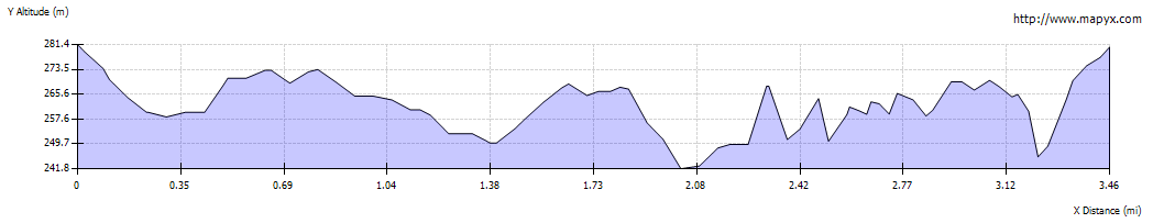
From the high points on the walk, the whole of the route is visible.
|

|
The final descent is the steepest, leading down to one of the turrets.
|
 "> ">
|
At the foot of the descent, follow the paved path, then continue to walk up the field path to return to the car park.
|