This walk is available to download as an ebook fromas an ebook - take the route description
with you on your Kindle, Kobo or other mobile device: Kobo epub version
;
Kindle version
| Maps: | Sheet 304: Darlington and Richmond. |
View Richmond in a larger map |
| Start: | NZ168006. This is a long term pay and display car park. There are alternative long term car parks on the route: Round Howe (NZ156008) and Station/Swimming Pool (NZ175008) - these are also pay and display. | |
| Route: | Click here to view the route superimposed on GoogleEarth
(GoogleEarth must be installed on your computer
in order to view - click here to download GoogleEarth).
The first part of the walk leads along roads up away from the river and onto a hillside track. After passing through woodland the path descends to the river and the route then stays fairly close to the river on the way back to Richmond. A footbridge leads to the southern bank. In some parts of this path there are slippery rocks to negotiate, with the route being flooded when the river is high (there alternatives further from the river). The route provides stunning views of the castle and of the weir. | |
| More info: |
Discover Richmondshire website; Wikipedia entry for Richmond. |
|
| Refreshments: | A wide choice in Richmond - we enjoyed afternoon tea at the Station (on the expensive side - but really good quality). | |
| Route profile: | 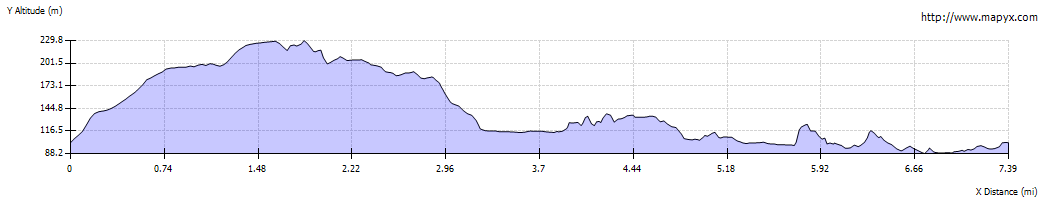
|
|

|
Leave the car park and turn left to walk up Cravengate. On your left you will be able to catch glimpses of Culloden Tower, a folly built to commemorate the battle of the same name. At the top of the hill bear left into Victoria Road. At the next junction, where the main road bears left, continue ahead to the right of West End Stores. The road is marked with a "No Through Road" sign. Continue along this road as it narrows to a single track country lane and then becomes a dirt track. |
|

|
After about a mile you will pass the signs pictured. Continue in the same direction. | |

|
After about another third of a mile the track leads into Whitecliffe Wood. | |

|
After walking through the wood you leave by passing through a metal gate. The clear path leads through a field to the wooden gate pictured above. Go through this and follow the path to the bottom corner of the next field, passing above Applegarth Youth Hostel. | |

|
Continue to follow the path to the right of the farm buildings pictured. | |

|
The path leads to a stile and gate. Cross the farm track pictured and then follow the finger post to the next wooden gate. | |

|
The path leads through further wooden gates until you reach a junction in paths marked by a finger post (shown in the photograph). Bear left, following the sign for Richmond and the River Swale. There's a waymarker on a wooden post ģ | |

|
ģ and then you come to this stile by a rusty metal gate. Cross the stile, walk by the wall for a few yards and then turn left through a gap in the wall. Walk down to another rusty iron gate. Cross the stile by the gate. | |

|
Go through gap in the wall close to remains of the building shown. Cross another wooden stile and then a short length of path leads to the river bank. | |

|
A series of stiles and waymarks on poles guide you alongside the river. At the location pictured it looks as though the path has been diverted away from the bank to prevent further erosion). | |

|
The river bends to the south east and the map shows that the right of way leads east, into the wood, over a stile at the left edge of the photograph. We followed the right of way, entered the woods and turned right - but later found we could have continued ahead on the clear grassy path! | |

|
After about 150 metres we came to a map showing permissive paths - at the point where the clear grassy path entered the wood. If we were to walk this way again, we would stay on the grassy path! | |

|
Leave the wood by climbing the stile to the left of a gateway ... | |

|
ģ the path leads around Lownethwaite Farm, shaded from view by tall conifers. Go through gate and over stile. The tall hedge is replaced by a high wooden fence and the path leads ģ | |

|
ģ to a wooden stile by a metal gate. | |

|
Follow this track for just less than half a mile. | |

|
When you reach the road, walk straight across to the marker post opposite. Walk down the narrow, stepped path through woodland to a picnic area and car park. Cross the car park ģ | |

|
ģ at the far corner of which there is a footbridge across the river.. | |

|
After crossing the bridge, go through the wooden gate on the left. | |

|
When the path divides there is a choice: we followed the left hand fork, but this path looks as though it could be flooded if the river is in spate. There are also places where the path is very slippery and crosses uneven rocks. The path on the right re-joins our route at Richmond Bridge. | |

|
The path follows fairly close to the river, just cutting a couple of corners where the river bends. | |

|
ģ before crossing a series of slippery, flat rocks right alongside the river. | |

|
ģ before crossing a series of slippery, flat rocks right alongside the river. | |

|
There are places where the path almost disappears into the river! However ģ | |

|
ģ it does improve ģ | |

|
ģ before emerging onto the road by Richmond Bridge. Turn right and cross the road ģ | |

|
ģ to follow the finger post pictured. | |

|
The path leads past a small car park, changing rooms and a football field. The route follows the river, before climbing through a narrow stretch of woodland. Leave the woodland through a kissing gate and turn left ģ | |

|
ģ to follow a grassy path. Go through the gate shown and carry on along the path which leads down to Station Bridge. | |

|
We turned right up this track, just before the building by the bridge (we found out afterwards that it is possible to go under the bridge and then up to the road). The track emerges on the road opposite ģ | |

|
ģ the Station - no longer a railway station, now a cinema, cafķ, heritage centre, gallery and office space. We stopped here for afternoon tea, before following the road over the bridge. | |

|
After crossing the bridge, take the tarmac path on the left. Walk down the path until it starts to curve to the right - then cross the grass to a path closer to the river. | |

|
The path leads past the weir and emerges at a car park. | |

|
Continue walking along the tree-lined path upstream, between the river and the road. When you come to the main road turn right, away from the river, into Bridge Street. | |

|
Follow the road as it bears to the left into the Green. Notice the building on the corner with two Georgian sundials:
the one pictured is on the south wall; the one round the corner on the east wall only shows the time until noon.
Return to the car park on your left. |
Other walks near here:
Back to:


