
- Seaham Harbour Virtual Walk - seaham.com
- Seaham - Wikipedia
- Durham’s Heritage Coast - This is Durham
- Seaham: On Chemical Beach - CITiZAN
- Seaham: Mad, bad and dangerous to know - CITiZAN
- East Durham Heritage & Lifeboat Centre
| Map: | Explorer 308 Durham & Sunderland |
|
|
| Start: | NZ 422 508 – Seaham Hall Car Park (free) | ||
| Route: | Our route was along beaches, promenade, roads and footpaths. This wasn’t the walk we had originally planned – we had intended a much shorter, circular route, starting off from the same place, but turning inland from the town centre. However, we decided to continue along the road to visit Blast Beach. The return trip, on a very hot, sunny afternoon did seem like a long trek along the road. It might have been better to do this as a linear walk, returning using the bus (checking after our return, at the time of writing, an hourly bus could have returned us to the start – more information in the route description). | ||
| Links to Route Files: | Ordnance Survey OS Maps online
(may only available to OSMaps subscribers) or .gpx
(exported from OS Maps app on Android device - can be imported into many devices).
|
||
| More info: |
|
|

|
Leave the car park and walk towards the top of the cliffs. You’re immediately faced with a choice: we went down the steps to the beach ( we could have turned right to follow the path at the top of the cliffs – this soon joins the road). |
")
|
At the foot of the steps we turned right, walking along the beach. This beach is noted for its sea glass, the result of waste from a local glass factory which was dumped in the sea. You’ll probably spot people sifting through the shingle (we spotted quite a few of these, but saw very little sea glass). |

|
We walked south along the beach, until we reached a point where the tide was almost up to the sea wall, so we walked up one of the ramps on to the lower promenade. |

|
Close to the end of the lower promenade we walked up the slope pictured to meet the B1287 (North Road). We continued south towards the town centre. |

|
This is one of a number of art works which commemorate Seaham’s heritage as a coal mining town with a harbour (extended to carry the coal to other parts of the country). |

|
Tommy is another sculpture, set in the centre of a large grassy area. This is a tribute to the fallen of WW1, created by Ray Lonsdale.
Continue walking south (or pause in one of the many coffee shops/cafes for some refreshment). Less than 100 metres beyond the end of the grassy area (Terrace Green) there is a roundabout. Follow the road left, down to the harbour and marina. |

|
Here there are more shops and a cafe, along with the East Durham & Lifeboat Heritage Centre –
unfortunately this was closed on our visit and at the time of writing remains closed due to vulnerability of volunteers during the Covid pandemic.
Perhaps it’s worth checking their website before visiting for more up to date information.
After exploring the harbour area, we returned up the road to the roundabout. Our original plan had been to walk inland along Castlereagh Road, then a footpath towards the railway station. Here we would have turned right towards Seaham Dene and then back to the car park. Instead we decided to turn left, continuing south, following ... |

|
… the pavement alongside the main A182. Note the name of the shopping centre, commemorating the poet, Lord Byron’s association with the town (there’s a sculpture of him in the town centre too). |

|
After just over three quarters of a mile (1.28 km) the sign shows that the coastal footpath parts way from the main road. Follow this path on your left, signed to Nose’s Point. |

|
The path leads above Chemical Beach — access to this beach is difficult, so we continued on ahead ... |

|
… to the top of Nose’s Point. It’s difficult to image that this grassy headland is the site of the coalmine Dawdon Pit. |

|
The view south, showing Nose’s Point on the left and Blast Beach curving round to the right. |

|
We chose to descend to Blast Beach via a fairly steep path – if you take this path, beware of slipping on the loose material (most likely spoil from coal mining). The alternative is to walk along the cliff top path the steps by which we returned. |

|
Looking back north to Nose’s Point and the path we used to descend to the beach. The raised area in the left foreground is industrial waste – there are signs warning against coming into contact with any water which has pooled in this area. |

|
A closer view looking back to Nose’s Head.
We continued to walk south for nearly half a mile (0.75 km) along the beach ... |

|
… to the first of the stacks. The photograph shows the view north, back to Nose’s Point. |

|
The next landmark is man-made rather than natural: a concrete relic from WW2 (Vickers MG Pillbox). In the shadows further south is a second stack. |

|
A closer view of the 2nd stack.
We walked to the end of the bach, then turned round, back towards the first of the stacks. Almost level with the stack ... |

|
… is this stepped path – we followed this ... |

|
… to where it joined the coastal path. We turned right ... |

|
… continuing to follow the coastal path. Information boards along the path tell of the area’s history. |

|
The path crosses this bridge before passing by the car park at Nose’s Point and re-joining the main road.
We decided to walk along the road back to the town centre (where we stopped again for refreshment) and then on to where we started. However, there is a bus from East Cliff Road that would have taken us back to Seaham Hall, close to the car park. This would be convenient for those who just wish to do a linear walk. Another alternative would be to park at Nose’s Point and catch the bus to Seaham Hall to then follow the route back to the car park at Nose’s Point. |

|
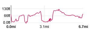
Nearly back at the car park after the approx 1ľ (2.8 km) walk, mostly at the side of the road.. |
All text and images © Graham Dean, June, 2021.
Back to:


