| Map: |
Explorer OL7 The English Lakes - South Eastern area (a few metres of the walk are on sheet OL6)
|
 |
|
| Start: |
SD 285 779 - Ulverston Railway Station. |
| Route: |
a short circular walk that leads through Ulverston, allowing you to explore the quirky town centre with its market,
independent shops and cafes (either on your way up the hill, on the way down, or both. Also not to be missed is the Laurel and Hardy Museum.
After leaving the town centre you climb Hoad Hill to the Sir John Barrow Monument (locally known as The Hoad).
The return to the town takes you along a woodland path by the side of Gill Bank Beck. |
| Links to Route Files: |
Ordnance Survey OS Maps online
(may only available to OSMaps subscribers) or .gpx
(exported from OS Maps app on Android device - can be imported into many devices).
|
| More info: |
|
 |
|
| Refreshments: |
Plenty of choice of cafes and pubs - we have enjoyed tea and coffee at the quirky The Fourpence Cafe & Shop on
King Street on our visits to Ulverston.
|

|
We left the station and turned left on to Conishead Road.
|
|
|

|
We then turned left again to follow Prince's Street.
|

|
We crossed the dual carriageway and walked ahead along Queen Street …
|

|
... to the Market Place. We saved exploring the town centre until our return, so again walked ahead into King Street.
|

|
At the mini roundabout we again went ahead onto Church Walk …
|

|
… which (not surprisingly) lead to the gates to the churchyard. We went through the first pair of gates and followed the path to the right,
alongside railings.
Where Church Walk turns to the left …
|

|
… leave the churchyard and follow Back Ford Park - here you have a clear view of the monument (and so can tell if it's open - a flag is flown when the monument
is open and you can climb the interior staircase)
|

|
Bear left up the slope or the steps …
|

|
… to follow the clear path - at the junction shown, we took the path on the left.
|

|
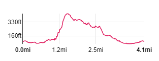
The path winds up the hill, with steps in places.
|

|
You walk below the monument and we cut across the grass …
|

|
… towards the monument.
|

|
There are splendid views …
|

|
... in all directions, with information boards pointing out what you can see (if it's clear enough).
|

|
Follow the clear path leading north east. This curves round to the north ...
|

|
… and then north west and almost due west as it descends.
|

|
Where the track bends round to the left, climb the ladder stile ahead. Follow the path …
|

|
… through woodland
|

|
A gate leads onto Town Bank Road. Cross the road, bearing right …
|

|
… to go through the metal kissing gate.
|

|
The grassy path lead s uphill, heading south west …
|

|
... and then descends …
|

|
... to meet Old Hall Road. Cross the road, bearing left to go through another metal kissing gate. the footpath sign indicates, The Gill ˝.
|

|
Almost immediately you cross what would have been the headrace for a watermill before passing through another metal kissing gate into …
|

|
... woodland at Gill Banks. Where the path divides, we took the lower right-hand route
(but as the paths join further along, it doesn't matter which fork you take).
|

|
The path widens as you reach part of Ulverston known as …
|

|
... the Gill. We walked across the car park and down Mill Street. We then turned right, back on to King Street
(but there are plenty of narrow lanes to explore - if you follow the remainder of our route back to the station,
it will take you through the Market Hall, to the Laurel and Hardy Museum and past the Laurel & Hardy statue.
|

|
We walked down King Street and turned left along Market Street. We then turned right into New Market Street and left to walk through the Market Hall.
Leaving the Market we turned right into …
|

|
… Brogden Street. From the museum we turned right to walk alongside the dual carriageway .. .
|

|
… to pose by the statue of Laurel and Hardy. We continued by the side of the dual carriageway to the pelican crossing at the junction with Queen Street -
cross and return to the station along Prince's Street.
|
All text and images © Graham Dean, November, 2019.


