or
OL2 Yorkshire Dales South & Western Map

- Bentham - Wikipedia
- River Wenning - Wikipedia
| Map: | Explorer OL 41 - Forest of Bowland & Ribblesdale or OL2 Yorkshire Dales South & Western Map |
|
|
| Start: | SD 651 693 - Harley Bank Car Park, Low Bentham (free) | ||
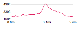
| Route: | A walk with plenty of variety: riverside, woodland and a chance to explore High Bentham. About a quarter of the route is along roads. There is an option to shorten the walk. | ||
| Links to Route Files: | Ordnance Survey OS Maps online
(may only available to OSMaps subscribers) or .gpx
(exported from OS Maps app on Android device - can be imported into many devices).
|
||
| More info: |
|
| |
| Refreshments: | There are pubs in both Low and High Bentham and a coffee shop in High Bentham. We did this walk just as the Covid-19 lockdown was easing. Some of the pubs were open, but we settled for ice-lollies from the Coop in High Bentham. |

|
Leave the car park and turn left ģ |

|
ģ to follow the B6480. |

|
Immediately after crossing the river, turn left along Mill Lane. The road passes under the railway bridge and then past cottages on the left. About ╝ mile after turning into Mill Lane ģ |

|
ģ a farm track and footpath can be seen on the right. Not quite so clear (until you arrive there) is a path on the left, entering the small wood immediately opposite the farm track. Follow the path into the wood ģ |

|
ģ where it follows the river upstream ģ |

|
ģ passing the weir and fish ladder. The weir is a reminder of Low Bentham's industrial past, when it was home to a textile mill. |

|
Climb a stone stile to follow the path through the field pictured. Another stone stile takes you into the next field ģ |

|
ģ at the far end of which a stone bridge takes you across a small tributary stream. Cross the stone stile pictured and continue walking alongside the edge of the field. After another stile ģ |

|
ģ the path descends a short flight of stone steps. The path bears left, between trees and bushes before ģ |

|
ģ a metal gate leads you into Riverside Caravan Park. |

|
Follow the footpath sign to join ģ |

|
ģ the main roadway through the centre of the site. Walk towards the site entrance and then, by the site shop, turn left to follow a roadway towards the river. Turn right before the river, again walking on a road between caravans. Where the road turns right ģ |

|
ģ look out for the small footpath sign pictured. Cross the stile shown and then a metal gate ģ |

|
ģ to follow the path pictured which crosses a wooden bridge and leads through ģ |

|
ģ through a small wood ģ |

|
ģ before joining the caravan park access road which ģ |

|
ģ emerges on to Thickrash Brow. To shorten the walk, you could turn left here, cross the river and then turn left again at the main road in Higher Bentham.
We walked across the road to follow the minor road opposite. |

|
Follow the road for some 200 metres and then take the footpath on the left ģ |

|
Follow the path pictured to cross a wooden stile next to a metal gate. At the end of the next field cross a stone stile ģ |

|
ģ to follow the path at the edge of the field (the OS map shows the path crossing the middle of the field, but we followed the much clearer route on the ground). We left this field passing between a wooden post and broken stone wall. At the end of the next field we walked through a gateway and continued staying close to the river ģ |

|
passing a area where the bank had suffered some serious erosion. A metal gate leads to a path bordered by a post and wire fence on the right and the river on the left. |

|
A narrow footbridge crosses a tributary stream and the path continues between a fence and the wooded river bank. Near to where the path crosses the Wenning, there's a (rather dilapidated) information board with local history notes. |

|
This bridge takes you across the River Wenning into a field (complete with cattle and a bull, as indicated by the yellow sign). Cross the bottom end of the field ģ |

|
ģ to where it looks as though there may have been a wooden stile. The metal gate was firmly locked - so we climbed it and then walked under the railway bridge. |

|
The clear track leads uphill between farm buildings. We continued uphill ģ |

|
ģ following Ridding Lane to its junction ģ |

|
ģ with the B6480. Turn left to follow the road into ģ |

|
ģ High Bentham. High Bentham has some interesting buildings and independent shops, along with pubs and a coffee shop. Follow the road through the small town ģ |

|
ģ until you reach the Horse and Farrier. Turn left down Duke Street, the narrow lane beyond the pub. |

|
The lane winds to the left between attractive cottages, (pictured) and then to the right ģ |

|
ģ where it next winds to the left climb the stone stile in the wall in front of you. Keep to the edge of the first field with a stone wall on your right. A stile takes you in to the next field ... |

|
ģ where a hedge forms the field boundary, again on your right. |

|
For the final few metres through this field, the path cuts across towards the bushes and railway line. Follow the hedge and fence then go through a gate and cross the railway line. Once across, the path leads you to the right to follow ģ |

|
ģ close to the river. The path continues alongside the river for almost half a mile ģ |

|
ģ passing through the narrow metal gate pictured (to the left of the wider gates) ģ |

|
ģ before continuing in the same direction (over this stile), while the river bends to the left. The path skirts lodges that are now used by a trout farm. |

|
The path turns to the right to take you under the railway and back to the B6480 in Low Bentham. Turn right to return to the car park. |
All text and images © Graham Dean, September, 2020.
Back to:


