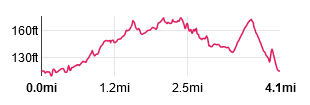
|
Leave the car park and turn right to walk along the narrow road to Ö
|
|
|

|
Ö cross the River Wyre.
|

|
Immediately after crossing the river, turn right to follow the waymarked footpath. At the time we did the walk there was a sign showing a ìtemporaryî footpath diversion
due to the permanent removal of a footbridge over the M6. Our (electronic) OS map still showed the bridge in place more than 12 months following its removal.
The path leads ...
|

|
Ö through attractive woodland alongside the Wyre, though not without obstacles on the day of our walk!
|

|
This is probably the point where the new, diverted footpath leads to the right, with the original path leading to the dismantled bridge gradually becoming overgrown.
|

|
This footbridge takes you out of the woodland. Follow the clear, newly fenced path ...
|

|
Ö which leads under the motorway.
|

|
Once under the bridge, the path turns to the left and leads alongside the field boundary (many of the fence posts are topped with yellow markers, indicating the route.
|

|
At the top of the field, turn right, along the boundary and then left through the gateway pictured. Once through the gateway head towards a distant pole
topped with a yellow marker, then bear right ...
|

|
Ö heading towards this derelict structure and the conifer pkantation. Walk alongside the plantation. At the corner of the field proceed through a wooden
kissing gate and turn right ...
|

|
Ö along a tarmac track. This leads past the main building of Guyís Farm Activity Centre. At the end of the stone wall in the picture ...
|

|
Ö bear left, following the white footprint sign (thatís just in front of Lin in the photo).
|

|
Walk alongside the grey painted building and through the doorway. Cross a short stretch of grass that leads to a wooden gate. Go through the gate and continue straight ahead ...
|

|
Ö through an open field. At the far end of the field, cross a footbridge and then a wooden gate to enter ...
|

|
Ö a caravan site. Turn left and follow the roadway towards the site reception building. Before reaching the building ...
|

|
Ö follow the waymarker to the right. This leads to large grey gates giving entrance to the fishery. Go through the gate with the large sign reading
WYREWAY FOOTPATH TO DOLPHINHOLME.
Once through the gate continue to follow footpath signs ...
|

|
Ö leading along the track pictured. The distant sign ...
|

|
Ö indicates the footpath takes a turn to the right. The narrow path runs through woodland with the River Wyre on your right.
|

|
The path ends at the gate picture. Go through the gate and turn right, crossing the river.
|

|
A few metres after crossing the river a finger post (mostly hidden in the bushes) shows that the route leads to the right.
There is supposed to be a footbridge across a stream ñ however when we did the walk this was broken. The vehicle access track was blocked by a locked gate.
Fortunately a fishery employee was there and let us through (otherwise weíd have had to climb the gate). The track leads to a car park. Turn to the left ...
|

|
Ö walking through the car park to the stile and continue along the path ...
|

|
Ö to climb over another stile. Walk through the field ...
|

|
Ö with a fence on your left. Climb over a wooden stile to enter ...
|

|
Ö woodland. The path follows close to a stream on your left and for a while runs along a low embankment (as pictured).
|

|
We did the walk after quite a dry period, but on this section there were still parts of the path which were very muddy.
|

|
The path emerges on a dirt track where a sign indicated that you should turn right along the track. After only 60 metres ...
|

|
Ö turn left off the track ...
|

|
Ö to follow another path through woodland.
|

|
After about 180 metres the path leads down steps to cross the footbridge pictured. Climb the steps on the opposite bank.
|

|
The path takes you to a stile and out of the woodland. Walk along the field, close to the field boundary on your right.
|

|
Leave the field by passing through a wooden kissing gate. A little further ahead, climb the wooden stile pictured and walk alongside a tall breeze block wall to emerge ...
|

|
Ö on the drive of Foxhouses Farm Cottages. Follow the drive until it meets a minor road. Turn right along the road. After about 320 metres turn right at a road junction.
The road leads over the motorway and back to Scorton Picnic Site.
|
All text and images © Graham Dean, April, 2021.