View Larger Map
The route described follows well defined paths, firstly around the lake, then above Harsop, before dropping down to follow Goldrill Beck back to the car park.
| Map: | Sheet OL5 The English Lakes - North Eastern area |
View Larger Map |
| Start: | Brotherswater car park(NY402133). Note, this is quite a small car park and soon fills up at weekends and in peak holiday periods. | |
| Route: | Click here to view the route superimposed on GoogleEarth (GoogleEarth must be installed on your computer
in order to view - click here to download GoogleEarth).
The route described follows well defined paths, firstly around the lake, then above Harsop, before dropping down to follow Goldrill Beck back to the car park. | |
| More info: | from Wikipedia | |
| Refreshments: | Brotherswater Inn. | |
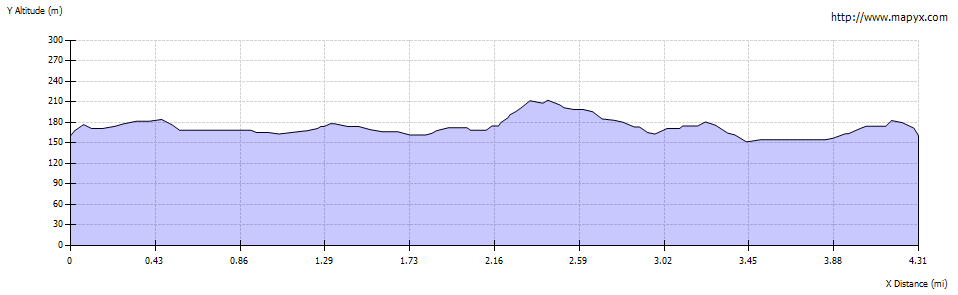
| Route profile: |
|

|
Leave the car park by following the track alongside the track heading south towards the lake. The track continues along the western shore of the lake, providing magnificent views across Brotherswater to Hartsop and beyond. | |

|
Continue along the track past the end of the lake until you reach a junction of paths just beyond Hartsop Hall. Turn left and follow the track across a field, a bridge and through Sykeside campsite. We called in at the Brotherswater Inn for some refreshment. However, if not stopping at the inn, turn left along the road leading north from the campsite. The road crosses a cattle grid. Just before reaching the main road there is a narrow path on the left. This path isn't shown on the map, and is easy to miss if you come out of the inn and walk north along the road - however it is much more pleasant than walking on the road. | |

|
As the lake is reached, the path emerges on to the road, but then continues away from the road where it is signposted
and there is a path (though not a right of way) marked on the map. Where the lake begins to narrow, the path joins the road.
Cross the road, go through the gate, following the footpath sign.
Cross the bridge over Hayeswater Gill and turn right on to the road when you reach Hartsop. Walk up through the hamlet until you reach a wooden signpost saying bridleway to the right and footpath to the left. Turn left along the footpath, which leads quite steeply uphill and through a wooden gate. Continue ahead, until the concrete surfaced track turns sharply to the left. Here follow the narrow path ahead (marked with a footpath sign. |
|

|
Go through a gate onto open fell. Cross Angle Tarn Beck below the waterfalls pictured. Where the path meets a track, bear right and ford another stream. After just less than half a mile turn sharp left (signposted bridleway, Deepdale Bridge)and cross the bridge. Immediately at the other side of the stream climb the stile an left and follow path alongside stream. The path emerges on the road. Cross the road and follow the path through the woods back to the car park. |
Other walks near here:
Red Tarn, from Glenridding - approx 6 miles
Patterdale to Silver Crag - 4 miles
Back to:


