|
There isnÆt a lot of room at the small car park at Grizedale Bridge! From the car park follow the narrow path down ...
|
|
|

|
ģ to a metal gate. Continue on the path through two wooden gates (at either side of a sheep pen?). After the 2nd gate bear left, taking the path leading to ...
|

|
ģ a wooden footbridge over Grizedale Brook. Cross the bridge and ...
|

|
ģ continue on the boardwalk. Go through a wooden kissing gate to enter Holme Wood.
|

|
ThereÆs boardwalk to follow for much of the way through the wood ¢ either the trees made our GPS track inaccurate ¢ or the concessionary path marked on the OS map isnÆt that accurate.
ItÆs probably a bit of both ¢ as the path runs to the south of Grizedale Brook until ...
|

|
ģ it crosses the brook. After crossing the bridge (with the remains of ford alongside) pass through a wooden kissing gate ģ
|

|
ģ a wider track leads alongside the brook as it flows into the reservoir. Stay on the track as passes through another gate and follows the reservoir bank until ...
|

|
ģ you reach a finger post. Take the path up the steps to the right, signposted for Nicky Nook and Scorton (it was just about readable).
A sign indicates that you are now on access land. The steep path ...
|

|
ģ (in places there are steps) leads ...
|

|
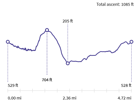
ģ to the trig point at the summit (just less than half a mile from entering the access land with a climb of about 900 feet.
|

|
Nicky Nook, coming in at less than 1000 feet, may not be the tallest hill in the Bowland AONB, but it does command impressive views if itÆs clear.
It was hazy on the day of our walk, so we could barely make out the outline of the Lakeland Fells.
|

|
From the trig point walk west and then north west, following the clear path downhill.
|

|
As with the climb up, there are steps in places. After just over half a mile go through a metal kissing gate ...
|

|
ģ to emerge at a T junction of roads. Take the road ahead. After just under ╝ mile turn right ...
|

|
ģ to walk along the track pictured ¢ the car park is for customers of the Applestore Cafe (where we stopped for refreshment).
|

|
Continue along the track beyond the cafe for about 1/3 mile ...
|

|
ģ when you meet a narrow road. Turn right and walk along the road for about 130 metres.
|

|
Bear left to go along the track towards PotterÆs Hill Farm (if the main gates are closed, there is a pedestrian gate to the right).
|

|
Although the OS map shows the footpath going through the farmyard ¢ we followed the alternative signs which directed us
over the stile pictured and around to the west and north of the farm buildings.
|

|
The signs directed through the gate pictured ...
|

|
ģ and then the gate shown here.
|

|
ThereÆs a good view of Nicky Nook on the right.
|

|
There were waymarkers on the trees ...
|

|
ģ and an occasional larger sign to follow before emerging turning left on a narrow road.
|

|
At the end of the road pictured turn right on to Brewers Lane. After a further 300 metres ...
|

|
ģ take the left fork towards Fell End Farm.
|

|
Again there are signs detouring around the farm buildings ¢ we went through the gate pictured on the right of the track ...
|

|
ģ following the waymarkers.
|

|
After passing the farm buildings and a wooden gate, look out for the wooden gate pictured to the left of the path. Go through this gate, followed by a couple more gates ...
|

|
ģ before you can see the car park in the distance. Turn left at the junction of paths to re-trace the short route back to the starting point.
|
All text and images © Graham Dean, March 2022.