Map: Sheet 2 Yorkshire Dales - South and West
Start: Sportsman's Inn, Cow Dub, Cowgill (SD768864)
This is basically a linear walk through the delightful valley of the River Dee, so it is possible to start at either end - and in either case there will be a pub waiting to refresh you before you return. We were staying at the Sportsman's Inn when we completed the walk - and can thoroughly recommend it's hospitality (check website for details of opening times). The route to Dent is entirely on the southern side of the River Dee. On the return leg it is mainly on the opposite side of the river. In both directions the walk goes out of its way to avoid the narrow roads which run at either side of the river. There are alternative paths - but they would involve more road walking.
If you start the walk at Dent, there is a public car park in the village.
We lost count of the number of stiles - though we have never been on a walk with so many, of every conceivable variety!
Turn left as you leave the pub following the road for about 400 metres. Follow the fingerpost on the left (signed for Ewegales). The path is clearly waymarked as you pass three sets of farm buildings - but after the third set, we couldn't find the path which descended to the road - so we followed the farm track instead. This brought us to the road at Ewegales Bridge. Turn left at the road, pass the fingerpost where we should have joined the road, and continue for about 200 metres.
Follow the Dales Way sign off to the left and ascend to a pine plantation. Walk through the woods, through a break in the trees where there is an imposing house, then back into the pines. The path continues to skirt the valley side, passing a number of farms. It continues to be well marked, with either yellow circles or arrows. Continue following the path signed for Sike Fold. In the field which has two stiles over the wall, take the right hand one. At Sike Fold take the path on the right, to re-join the road.
Cross the road and follow the path to Tommy Bridge. Do not cross the bridge, but follow the path until it re-joins the road. Turn right and walk along the road for a few metres then taking the path on the right. The path follows the stream for about 400 metres, then it is possible to turn left towards Double Croft. The path here follows the field boundary, but it was not marked, nor visible on the ground. By the buildings, cross a track, and follow the bank of a stream on your left. Cross a small footbridge just before the path follows the edge of a playing field. The path joins the road next to Church Bridge. Turn left and follow the road into the village.
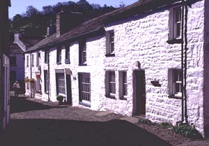
This is a village in a time warp! The cobbled streets are picturesque, but a motorist's nightmare! There are two pubs (which seem to take it in turn to open during the winter), three tea rooms (only one of which was open on the February weekday we visited), plus two shops, and also a couple of galleries.
Whoever painted the yellow spots to mark the footpaths hadn't been on the north of the valley as recently as they had the south - some of the spots were very faint!
Leave the village by walking back along the road which passes to the left of the George and Dragon. Cross Church Bridge, and turn left at the minor road, then follow the drive on your immediate right. Before you come to the buildings, take the footpath on the right. This path skirts the contours, passing a number of farms and other buildings. Careful examination of the O.S. map will show which side of the buildings to walk, and the stiles are mostly fairly obvious (if we found them, they must be). At Cross House, follow the drive down to the road.
At the road turn right, then follow the bridlepath sign pointing down to the left. The path follows the top side of a fence, then curves down towards Tommy Bridge. Don't cross the bridge, but walk straight ahead. Just before the next footbridge, take the path uphill through a field to its north west corner. At the road turn right.
Follow the road (this is the longest stretch of road - about 600 metres) until you come to a track on the left (signed Cowgill). Follow this track up, through the group of buildings and then along the hillside. The path again skirts the contours, passes a number of groups of buildings, and takes you over a number of stiles, before dropping to the back of a farm. The path then turns left, cutting across a field from corner to corner. Five more field boundaries to cross before you emerge on a track. Turn right. The map shows that you are on a road, but it seemed to have lost most of its surface! Walk down to re-join the main road next to the Church at Cowgill.
Turn right and then left to cross Ewegales Bridge. Immediately at the far side, turn left to follow the path along the river bank. This rejoins the road at the next bridge. Continue ahead, along the road to The Sportsman's Inn.
Back to:
Walks Index
Graham Dean's Home Page