Howth Head (Republic of Ireland) (approx. 8 miles)
Based on a walk from Paddy Dillon Exploring the South of Ireland.
Start: Howth DART Station
Howth Head marks the north of Dublin Bay. About three quarters of the route
follows coastal road or footpath. The remainder of the walk is along suburban
roads, which cut across the neck of the headland. Sections of the coastal path
are very rugged - there are also sections where nettles and brambles encroach on
the path. We walked in shorts and sandals - so our legs were scratched and stung
by the tie we returned to Howth Station. The peace and quiet of the walk made a
refreshing contrast to Dublin's hustle and bustle!
Howth Station - The Great Bailey (approx. 3 miles)
 From the station turn left to walk along the coast road,
with the harbour on your left, and village shops and cafes, etc on the right.
From the pier (and public toilets) follow Balscadden Road up the hill to the
right. As the road climbs, mook back to admire the view. Follow the road marked
as a cul-de-sac, which passes Balscadden House (once the home of oet W.B.
Yeats). The road ends at a car park, but a well-trodden path continues beyond
bollards.
From the station turn left to walk along the coast road,
with the harbour on your left, and village shops and cafes, etc on the right.
From the pier (and public toilets) follow Balscadden Road up the hill to the
right. As the road climbs, mook back to admire the view. Follow the road marked
as a cul-de-sac, which passes Balscadden House (once the home of oet W.B.
Yeats). The road ends at a car park, but a well-trodden path continues beyond
bollards.
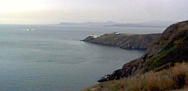
It is important to keep to the path, because the cliff below and the slope
above can be dangerous. The path climbs gently until the Baily Lighthouse comes
into view. From here the track descends to the lighthouse access road. Cross the
road and find another path, between dense bushes.
The Great Bailey - Howth Station (approx. 5 miles)
The bushes look as if they have escaped from the neighbouring gardens. When
you reach the junction with other paths, turn right, then left. Further along,
next to a lapboard fence, turn left again. After turning round Drumleck Point,
the views of the lighthouse are lost. Further on there is a short flight of
steps. Between here and the road there are a couple of small, pebble-strewn
beaches. We paused for a reston one of these. There is also a stretch of the
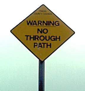
path which is a tricky scramble across a steep, rocky slope. The sign shown in
the photograph is at the far end of this section - to distract people from
completing the walk in an anti-clockwise direction?
Beyond a Martello tower, follow the road. At the first junction turn left to
follow Strand Road (though we found no re-assuring street name sign). Continue
to the junction with Carrickbrack Road, where you turn right, then left at
traffic lights into Offington Park. At the end of this suburban stretch, turn
right onto Howth Road, which leads back to the DART station and harbour.
Back to:
Walks Index
Graham Dean's Home Page