
- Bolton-le-Sands - Wikipedia
- Carnforth - Wikipedia
- Carnforth Station Heritage Centre - Carnforth Station
- Lancaster Canal - Wikipedia
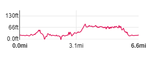
| Map: | Explorer 296 - Lancaster, Morecambe & Fleetwood (a very, very short length of the walk is on Sheet OL7).
|
|
|
| Start: | SD 474 683 - We parked on the foreshore car park near Red Bank Farm at Bolton-le-Sands. If you wish to use public transport, there are various options, including starting from bus stops on the A6 at Bolton-le-Sands, where there are regular services from Morecambe, Lancaster and Carnforth. The other option is to start from Carnforth, which can be reached by bus or train | ||
| Route: | from the car park you walk along the foreshore along a well-defined path. The path deteriorates and you have to pick your way carefully over salt marsh. At Carnforth there is a short walk along roads (and the station platform), before joining the canal towpath, then again a short stretch along roads before returning to the foreshore. | ||
| Links to Route Files: | Ordnance Survey OS Maps online
(may only available to OSMaps subscribers) or .gpx
(exported from OS Maps app on Android device - can be imported into many devices).
|
||
| More info: |
|
| |
| Refreshments: | We enjoyed scones, jam and cream with a pot of tea at the Refreshment Room on Carnforth Station, however, there's lots of choice on the walk, including pubs and cafes in Carnforth and pubs in Bolton-le-Sands. There is also Archer's Café, close to the start/end of the walk. |

|
We started from the car park near Red Bank Farm - to start the route at Carnforth Railway Station click here. |

|
Follow the clear path along the sea defence, heading north east. After a short distance the path descends to the level of the salt marsh.
The path joins a road by a small car park.
Turn left to walk along the road for about 50 yards, towards a large, white painted house … |

|
... and turn left, following access road to Bay View caravan and camping site (though the sign says, "Private Road to Bolton Holmes Farm." Where the road bears right to enter the caravan site, continue ahead along the edge of the salt marsh. |

|
For a short distance, the path is good - but then the clear path enters the caravan site on the right. Our route continues across the salt marsh, which is often wet underfoot and you have to dodge round, or jump over, pools of water. |

|
From this point you are following the River Keer, and the going becomes a little easier … |

|
… though scrambling over the rocks is not easy going, but it is change from dodging the mud and water of the marsh. The route passes a smaller farm caravan site before … |

|
… you pass through the wooden gate pictured. |

|
A short distance on you come to the gateway and stile pictured. Climb the stile and bear left along Shore Road. |

|
Continue along the road as it turns to head east, then after this point turns to the south east. |

|
The road turns east again and takes you under two railway bridges … |

|
… before meeting Warton Road. Turn right and walk under another railway bridge (pictured). |

|
You shortly cross a bridge over the railway. Bear right through the gateway pictured (if you're here before 10 am or after 4 pm continue along Warton Road). Turn right through the gateway and you will see a white fence and gate leading onto … |

|
... the station platform. The Heritage Centre is a must for both railway enthusiasts and fans of the famous David Lean film. We had a break here at the Refreshment Room before heading along the platform to the subway. At the foot of the slope turn left, following the exit signs. |

|
At the top of the slope, turn right to leave the station by crossing the car park. Turn right again to re-join Warton Road … |

|
… which becomes Market Street. Walk up Market Street to the traffic lights. Go straight across the main road (A6), passing the side of the County Hotel and a couple of terraces of houses. |

|
Just before coming to the bridge over the canal, turn right onto the path leading to the canal towpath. Turn right, following signs for Lancaster. |

|
Navigation is pretty straightforward ... |

|
... for the next couple of miles, as you follow the towpath.
Immediately after passing under … |

|
... the third bridge … |

|
... turn right up the path pictured. At the top of the slope … |

|
... turn left. following the track down to … |

|
… the main road (A6). Cross the road, turn right and then immediately left into another Mill Lane. |

|
Follow the road through housing and over a railway bridge. You pass between a garden centre and a furniture warehouse … |

|
... before turning left to re-join the path back to the car park.
(If you started the walk at Carnforth, you can turn right here, following the road towards a large, white painted house … click here to continue) |
Other walks near here:
All text and images © Graham Dean, May, 2019.
Back to:


