
- Latrigg - from Wikipedia
- Keswick Railway Footpath - Visit Cumbria
- Keswick - from Wikipedia
Unfortunately the first part of this route is no longer walkable - the heavy flooding in December 2015 did damage to the railway footpath and washed away bridges. The earlier version of the walk, follows less of the railway path - but still crosses at least one bridge that is no longer there. As soon as I hear that repairs are completed, I'll remove this note.
This walk is available to download as an e book in Kindle format from Amazon - take the route description with you on your mobile device. There is also an earlier version, on this website, walking clockwise and following a slightly different route.
| Maps: | Sheet OL4 The English Lakes - North Western area.. |
| |
| Start & Finish: | NY 270 238 - Keswick Leisure Pool car park (there is free, unlimited parking on parts of Brundholme Road). | ||
| Route: | Latrigg may only be only one third of the height of the tallest Lake District peaks, nevertheless it provides impressive views. Most of the route follows clear paths or tracks, though part of the ascent is along a grassy path, which may not always be clear on the ground. As well as the magnificent views, the walk passes along riverside tracks and through woodland. | ||
| Links to route files: | .gpx (for many handheld devices) .kml (Google Earth - Google Earth must be installed on the device in order to open this file) | ||
| More info: |
|
||
| Refreshments: | There's plenty of choice in Keswick, but our (very different) favourites are The Square Orange and Bryson's. | ||
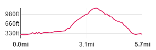
| Route profile: |
|
||

|
From the Leisure Pool car park, follow the railway footpath, passing the old station building (now part of a hotel). |

|
The track is mainly level and well surfaced. |

|
It passes below the A66 Keswick northern bypass - this sleek, concrete bridge may not blend well with the wooded valley that it straddles, but it has won awards, including the Best Civil Engineering Structure of the Century in 1999. From here the path drops slightly ģ |

|
ģ to follow a dramatic diversion from the original railway line (which went through a tunnel at this point - the top of the entrance can still be seen). The wooden walkway rejoins the old trackbed ģ |

|
ģ to pass the remains of the platform at Low Briery. |

|
The River Greta is never very far away from the track, which crosses it a number of times. |

|
Leave the railway path by going through the gate on the left, opposite the railway workers shelter (which contains information boards). |

|
From the gate a very short track leads to a second gate. Go through this and turn left ģ |

|
To follow a narrow access road. |

|
Follow the road as it winds uphill, ignoring paths off to the right, until you reach the pictured gate and sign. Go through the gate and bear right ģ |

|
ģ to climb the stile by this gate. The sign says Skiddaw 4 miles. |

|
Where the path divides again - again take the right fork - this time Latrigg is included on the sign! |

|
The path here provides a splendid view back to Blencathra ģ |

|
ģ and to the left across to St John's in the Vale. |

|
Go through the gate and then ģ |

|
ģ leave the clearer track to follow the less clear, grassy path up the fellside. |

|
The path leads towards the corner of field boundaries, the bears left, climbing gently. |

|
Go through the gate and follow the clearer path which skirts to the left of the highest point of the fell (it's a shame there is no trig point to mark the highest point). |

| The path starts to descend ģ |

|
ģ opening up views of Keswick, Derwentwater and Borrowdale to the left - with Bassenthawite out of shot to the right. On a good day, this viewpoint is often busy - but on the day we completed the walk, it was so windy that just staying on your feet was a difficult task. |

|
From the viewpoint the path leads to the right heading roughly north as it descends. |

|
At this junction of paths bear left ģ |

|
And follow the zig-zags where the fellside is steeper. At a junction of paths, turn left ģ |

|
ģ to follow this path in a south westerly direction. |

|
The path continues to descend, winding to the south before leading through the gate pictured. |

|
The views are more restricted as the path levels out ģ |

|
ģ and takes you back across the A66 - this time passing over it. |

|
Turn left to walk along Brundholme Road - to start off with there's a pavement on the right |

|
A little further along the pavement ends - but there's a narrow path running parallel to the road. |

|
Turn right where the narrow path emerges on to a road, then turn immediately left to continue along Brundholme Road. |

|
At the roundabout, turn right to return to your starting point. |
Other walks near here:
All text and images ©Graham Dean, November, 2015.
Back to:


