View Larger Map
The route is mainly along clear riverside footpaths and disused railway tracks - but there are a couple of steep ascents and descents.
Tideswell Dale from Peak District National Park Authority
Litton Mill from Peakland Heritage
| Map: | Sheet OL24 Peak District - White Peak area |
View Larger Map |
| Start: | Tideswell Dale Car Park (SK153741). | |
| Route: | Click here to view the route superimposed on GoogleEarth
(GoogleEarth must be installed on your computer
in order to view - click here to download GoogleEarth).
The route is mainly along clear riverside footpaths and disused railway tracks - but there are a couple of steep ascents and descents. | |
| More info: | Monsal Trail from Wikipedia
Tideswell Dale from Peak District National Park Authority Litton Mill from Peakland Heritage | |
| Refreshments: | There's plenty of choice in Tideswell before or after the walk. Along the route there is a choice of the Stables Bar at the Monsal Head Hotel; the Packhorse Inn on the main street in Little Longstone or Hobb's Cafe and Crafts, which like the Monsal Head Hotel, has stunning views. | |
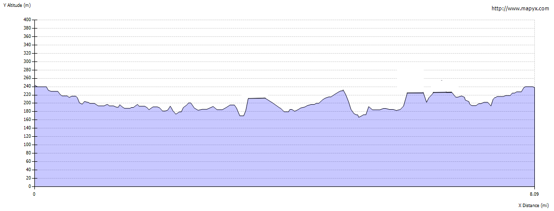
| Route profile: |
|
|

|
Walk through the gate by the toilets at the southern end of the car park. The path has a smooth surface, suitable for wheelchair users. |
|

|
The path divides, one route either side of the stream. As it rejoins further down the dale, it doesn't matter which route you take. After the paths rejoin, walk through a gate and continue down the dale to meet a minor road. | |

|
Turn left along the road and walk through the hamlet of Litton Mill, passing the cottages pictured. |
|

|
Continue ahead through the gates pictured - the route here is a concessionary path. This mill has been renovated in the ten years since we last walked along this part of the dale. Once past the main former mill building turn right to cross the former tailrace, then left to walk along the path by the River Wye. | |

|
The path continues alongside the river. At some point Miller's Dale become Water-cum-Jolly Dale - why it's not Wyedale for the whole length of the valley I don't know. The valley side on the left becomes steeper, until you walk below the cliffs pictured below. This part of the path is subject to flooding after heavy rain. The path curves to the right and leads over a weir. | |

|
After crossing the weir, the path leads up the hillside, away from the river. It joins the Monsal Trail after about ¼ mile. Turn left to follow the trail towards Monsal Head. | |

|
Continue along the track, being wary of cyclists - they were much greater in number than on previous walks along the track - this may have been due to the novelty of the tunnels having recently re-opened, but is more than likely to be a permanent feature, now that it is possible to cycle for greater distances along the trail. Most of the cyclists we encountered were considerate of other users, but there were a couple who were treating it as a race track! | |

|
The track leads over the Headstone viaduct (more commonly known as the Monsal head viaduct), which has impressive views along the Wye in both directions. Continue along the track to enter the Headstone tunnel. | |

|
The tunnel is well lit and surfaced - for more details about the re-opening of the tunnels follow this link. After emerging from the tunnel you pass under a bridge, before coming to a footpath signed Little Longstone. Turn left to follow this path. | |

|
The path leads through fields to emerge on a minor road. Turn left and pass through the village of Little Longstone, stop for refreshments at the Packhorse Inn or continue along the road to cross B6465. Here there is the Monsal Head Hotel and Hobb's Cafe, along with... | |

|
...this magnificent view looking up the valley (the view is equally impressive look down the valley)
- photographs can't do it justice! Follow the steep footpath opposite the cafe. Keep straight on to the valley bottom and then follow the path ahead to cottages. At a junction of paths, turn left... |
|

|
... to cross the river by the footbridge pictured here. The narrow path leads uphill to a bridge over the Monsal Trail. Don't cross the bridge, but climb the stile on the right to drop down to the track. Turn right onto the track, to follow about half a mile of track which was walked in the opposite direction earlier. | |

|
Continue ahead, through Cressbrook Tunnel. | |

|
Between Cressbrook and Litton Tunnels there is opportunity to see a view which was previously just a fleeting glimpse from a railway carriage. There is also a listening post which has some short audio tracks related to the trail. | |

|
The Litton Tunnel is the final tunnel included in this walk. | |

|
About ¼ mile after leaving the tunnel, look out for a sign to Litton Mill on the right (it's just before a bridge over the trail). Follow the steep path as it zig zags down the hillside. | |

|
At the bottom of the path, cross the footbridge and continue ahead to meet the road. Turn left along the road, retracing your original route from here back to the car park. |
Other walks near here:
Back to:


