| Maps:
|
Sheet OL30 Yorkshire Dales - Northern and Central
areas.
|
View Semer Water in a larger map
|
| Start: |
SD921875. Pay and display car park on shingle beach at north of lake (pay at Low Blean Farm). |
|
Route:
| Click here to view the route superimposed on GoogleEarth
(GoogleEarth must be installed on your computer
in order to view - click here to download GoogleEarth).
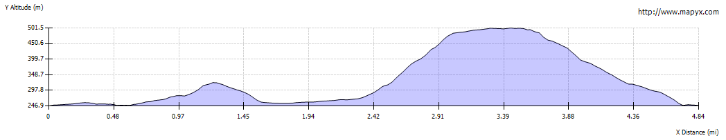
Semer Water is one of only two natural lakes in the Yorkshire Dales. This walk takes you around the lake,
starting quite gently, following clear paths and tracks up to Stalling Busk, then down a lane to Marsett.
From Marsett there is a steep climb up a grassy path to the ridge above the lake. It's then downhill to
Countersett and along the road back to the car park. If the climb is too much, you can follow the road from
Marsett to Countersett, but the views from the ridge do reward the effort of the climb.
|
|
More info:
|
Lake Semerwater website;
Wikipedia entry for Semerwater.
|
|
Refreshments: |
pub and tearooms in Bainbridge, or wider choice in Hawes.
|
|
| Route profile: |
|

|
Leave the car park and turn right onto the narrow road.
|
|

|
After about 400 yards you reach Low Blean Farm (where you should have paid the car park charge and obtained the
pay and display ticket).
|

|
Climb the ladder stile opposite the farm and walk along the clear footpath. A gated stile leads into ģ
|

|
ģ the next field. A stone stile takes you into the next field. The path runs to the right of the field barn (pictured)
and over a stone stile. Following this there is a gated stile ģ
|

|
ģ then the wooden stile in this photograph. The path continues ģ
|

|
ģ through this gateway (the large gate looked as though it hadn't been closed for a long time).
|

|
To the right of the path we explored the ruins of
Stalling Busk Old Church.
|

|
After leaving the ruined church, head towards the gate pictured. Once through the gate, we took the left fork
(though the right hand path cuts both a corner and a brief climb). Pass through a wooden gate ģ
|

|
ģ and follow path by a stone wall on the right. At the top the path is stepped and then leads over a gated stile ģ
|

|
ģ to cross a farm track and emerges on a surfaced road by a finger post. Turn right along the road.
|

|
The new church is on your left. Turn right down the track (Busk Lane) that leaves the road at the far corner of the churchyard.
|

|
Follow the track downhill. In places it is quite steep and the stones are slippery when wet. Continue along the lane as it levels out and crosses ģ
|

|
ģ a concrete bridge. Continue along the lane ģ
|

|
At this point the river seems to have burst its bank - route to the left appears to be well used.
Follow this narrow path round the back of the tree ģ
|

|
ģ until the water runs back into the stream and you can re-join the stony track.
|

|
The track leads to a ford, but follow the path to the left to cross the beck by means of a footbridge.
|

| The lane continues to run alongside the stream and through a couple of gates until, ģ

|
ģ you reach the green at Marsett. Walk across the grass, re-joining the road to the right of the telephone box.
Turn right along the road and cross Marsett Beck.
|

|
If you wish to avoid the steep climb and shorten the route by over a mile, continue along the road.
But to enjoy the magnificent views from the ridge, turn left to follow a stony track signposted for Burterestt and Hawes.
|

|
After a little over 200 yards, look out for this metal gate on the right. Climb the stile to the left of it.
|

|
The path leads quite steeply up the hillside, over a stile, through this gateway and over another stile by a metal gate.
|

|
When you reach this ladder stile you're nearly at the top!
|

|
Before reaching the highest point, we turned right to follow a grassy path north east. Although it wasn't very clear to start with ģ
|

|
ģ it became clearer and lead to ģ
|

|
ģ this gateway. The path passed through an area of shakeholes and provided superb viewsģ
|

|
ģ before starting to descend to the gateway and stile pictured.
|

|
The path winds fairly gently downhill.
|

|
Continue to follow the path through this gate and then a wooden gateģ
|

|
ģ and finally the wooden gate pictured. Then turn right onto a narrow road. Continue to walk along the road, passing a sign saying that you are in Countersett.
|

|
At the road junction pictured turn right and then immediately left, in the direction of Stalling Busk. The road descends steeply to return you to the car park at Semer Water.
|
All text and images ©Graham Dean, October 2013.


