| Maps:
|
Sheet OL4: The English Lakes: North Western Area.
|
View Walla Crag starting points in a larger map
|
| Start: |
That depends: we considered that we started at the Keswick boat landing stage (NY264227)
where we caught the launch to the landing stage at Ashness Gateway (NY268204) - this was where we actually commenced
walking. If you're feeling more energetic the walk can be started by walking along Derwentwater's shore path from
Keswick instead of taking the launch. There is a large pay and display car park at Lakeside. |
|
Route:
| Click here to view the route superimposed on GoogleEarth
(GoogleEarth must be installed on your computer
in order to view - click here to download GoogleEarth).
This route may not climb very high, but it does provide stunning views over Derwentwater, Bassenthwaite Lake and Borrowdale.
Most of the route is along paths across open fell. The final stage passes through Springs, Castlehead and Cockshot Woods.
|
|
More info:
|
Keswick Launch Company timetables and information;
Wikipedia entryfor Derwentwater;
Wikipedia entryfor Keswick.
|
|
Refreshments: |
There's lots of choice in Keswick: our favourites are (very different) the
Square Orange and Bryson's.
A welcome surprise on the route was coming across a new coffee shop, converted from a farm building at Springs Farm.
|
|
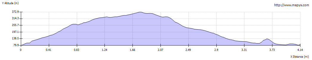
| Route profile: |
|

|
We chose to start the walk by taking the launch from the landing stage, clockwise to Ashness Gateway.
(Those who wish to walk the whole distance should follow the signs to Friar's Crag. From here the path doubles
back and then south east to Strandshag Bay. Then head inland and enter woodland. At junction with access road turn
right towards Stable Hills. Follow the concessionary path round Calfclose Bay and continue south to the landing stage.)
|
|

|
From the landing stage at Ashness Gateway, walk along to the road. Cross the B5289 Borrowdale Road and walk
up the road signposted to Ashness Bridge and Watendlath.
|

|
After just less than half a mile you reach the Lake District's most photographed bridge!
Take the path over rocks on the left, immediately before the bridge.
|

|
After crossing the rocks there is a clear footpath which leads to ģ
|

|
ģ a gateway and a wooden stile. Cross the stile and continue ahead. At a junction of paths,
turn left along a stony path, heading up towards a narrow wooden gate in a stone wall.
Continue ahead, ignoring the gate on left.
|

|
Continue to follow the stony path up the hill ģ
|

|
ģ pausing to admire the view behind.
|

|
The path continues to climb up the hillside, before turning to the east and levelling out. It turns to the north again and ģ
|

|
ģ crosses a couple of streams. Climb more gently and the path meets a stone wall on the left.
|

|
Look for a stile in the wall and cross it ģ
|

|
ģ to admire the views.
|

|
Walk back to a cairn and then cross another stile in the wall. Turn left ģ
|

|
ģ to follow the path downhill.
|

|
This provides views over the valley to the east of Keswick.
|

|
Pass through the gate pictured.
|

|
The track leads to the ford shown. No need to paddle: there's a footbridge in the trees on the left.
Turn left to walk along a narrow road. Follow the road for a little more than 100 metres, then follow ģ
|

|
ģ a narrow footpath on the left.
|

|
Re-cross the stream and turn immediately right.
|

|
The path follows the direction of the stream and leads to ģ.
|

|
ģ a kissing gate. Go through the gate. Another path joins from the left and you pass a transmitter mast.
The path turns sharply to the right and then you come to a t-junction.
|

|
Turn left, continuing downhill through woodland.
|

|
A welcome sight as we left the woodland was this coffee shop - needless to say we stopped for refreshment,
before continuing ...
|

|
ģ to walk along Springs Road.
|

|
After about a quarter of a mile take the footpath on the left.
|

|
The path leads into Castlehead Wood ģ
|

|
ģ where the path immediately divides - we choose to turn right and follow the clockwise route through the wood.
|

|
Where the path next divides, take the left fork (the one on the right leads nowhere). The path leads gently
uphill and divides again (by the corner of a fence). This time take the right fork.
|

|
This leads to steps down to the road. Cross the road and turn left along the footpath running parallel to the road.
|

|
Leave this path at the finger post pictured. Descend steps ģ
|

|
ģ to walk along this narrow path.
|

|
Walk through Cockshot Wood - we took the path straight ahead.
|

|
The path emerges from the Wood opposite the landing stages.
|


