View Larger Map
The route mainly follows clear paths, roads and tracks. There is a section above Troller's Gill where the path may be indistinct.
Troller's Gill from Wikipedia
Troller's Gill from Mysterious Britain
| Map: | Sheet OL2 Yorkshire Dales: Southern and Western Areas |
View Larger Map |
| Start: | Car park on the Green(SE032611). | |
| Route: | Click here to view the route superimposed on GoogleEarth
(GoogleEarth must be installed on your computer
in order to view - click here to download GoogleEarth).
The route mainly follows clear paths, roads and tracks. There is a section above Troller's Gill where the path may be indistinct. | |
| More info: |
Burnsall from Wikipedia Troller's Gill from Wikipedia Troller's Gill from Mysterious Britain | |
| Refreshments: | A variety of pubs and tea rooms in Burnsall, Appletreewick and at Parcevall Gardens. We enjoyed a drink at the Craven Arms, Appletreewick (on our previous visit we enjoyed the leek and potato soup). | |
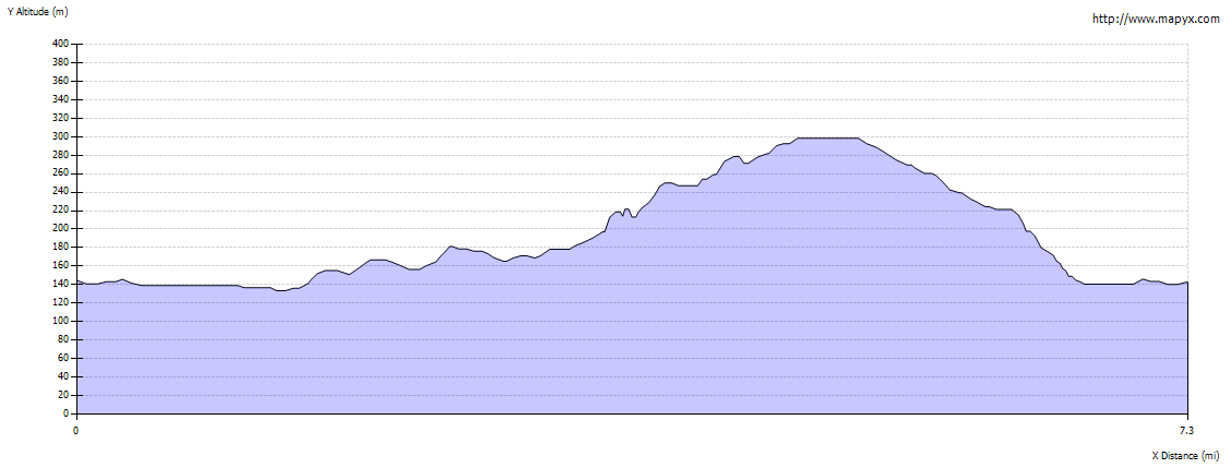
| Route profile: |
|
|

|
From the village car park, cross the bridge and then turn into the field on the right (in summer this field is used as a car park). Walk up a slight incline, and follow the path along the river bank. This section of the route follows the Dales Way. The path continues in the same direction, through Woodhouse Farm, whilst the river turns to the south. The river and path rejoin - continue along the path until there is a touring caravan/camping site on the left. |
|

|
Turn left to follow the signposted path along the far side of the camp site to join the road. | |

|
Turn right along the road towards Appletreewick. Notice the stocks on the left, just before the Craven Arms. The leek and potato soup and the open fires were equally warming on the cold January day when we first visited! On our second visit the beer and cider provided welcome refreshment. | |

|
From the pub, continue along the road through the village. Look out for Mock Beggar Hall on the left.
Carry straight on at the road junction which is about ¼ mile beyond the church. At the next road
junction take the right fork (no through road sign). Continue through the hamlet
of Skyreholme, to a road junction in Middle Skyreholme. Take the left fork (signposted Parcevall Hall). The road bends to the right. Do not cross over Fir Beck - but cross the stile on the left, immediately before the bridge. Follow this path for about ¼ mile. |
|

|
At a junction of paths shown in the picture - take the right fork. This path isn't marked on my OS map - but this is access land. The path leads to the stream. Follow this upstream, past where the water emerges from springs. Continue alongside the dry river bed which leads to the bottom of Troller's Gill. | |

|
The Gill is a narrow valley - it seemed much more eerie on our first visit, with the low
winter sun, than on our walk in May - nevertheless it is easy to see why tales of
trolls, sprites and the black dog legend have grown around this place. Take care walking over the
limestone boulders as you make your way through the ravine.
The valley opens out, and the stream is met again - despite the dramatic valley, there are no large potholes - the stream just sinks through small, loose rocks in the stream bed. After crossing and re-crossing the river bed, the path is easier to follow on the right of the beck. |
|

|
You come to a field boundary where a small round marker points across a plank bridge. The path runs downstream for a few yards to a ladder stile. | |

|
Once over the stile, the path (not marked on our map) is indistinct, but there are a couple of marker posts (I'm sure that there were more when we walked the route in 2001). Walk over the shoulder of the high ground, down to join a clear path. | |

|
Turn right, then after a few yards, just beyond a finger post, turn left. Again the path is not distinct, but a single wooden pole helps to keep you walking in the right direction. From the top of the rise you then head towards a gated stile in the stone wall ahead. Once over the stile, turn left to walk along the road. | |

|
After about 100 yards the road bends to the left. My OS map shows a footpath straight ahead, but we continued along the road for another 100 yards or so, to the gateway and signpost pictured here. Follow the sign (which reads, Bridleway, Hartlington 1¾). | |

|
This track continues in the same direction for just less than a mile, then turns slightly to the right. At the next junction of paths keep straight ahead. The track drops down to provide a view of Hartlington Hall, then bends to the left. When the lane emerges at the road, go straight across to follow the path to Woodhouse Farm. On meeting the Dales Way, turn right to re-trace your steps to Burnsall. |
Other walks near here:
| Burnsall to Grassington via Hebden |  |
| Kettlewell,Arncliffe and Starbottom | |
| Janet's Foss, Goredale Scar & Malham Cove | |
| Buckden |
Back to:


