
- Bowlees Visitor Centre - North Pennines ANOB
- Low Force Wikipedia
- High Force Wikipedia
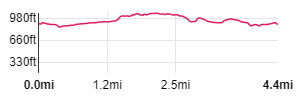
| Map: | Sheet OL31 North Pennines: Teesdale & Weardale
|
|
|
| Start: | NY 9078 283 - Bowlees Car Park (park & donate) | ||
| Route: | the route takes in clear, riverside paths, farm tracks along with open fields and some short stretches of road. You walk alongside Low Force, whilst the route also provides views of High Force - a longer route described in this leaflet describes extensions which will provide a better view of High Force from the northern bank. | ||
| Links to Route Files: | Ordnance Survey OS Maps online
(may only available to OSMaps subscribers) or .gpx
(exported from OS Maps app on Android device - can be imported into many devices).
|
||
| More info: |
|
| |
| Refreshments: | High Force Hotel isn't too far from the route - but we drove back to Middleton-in-Teesdale where there is a choice of cafes and pubs. |

|
From Bowlees car park, take the bridge across Bowlee Beck and then follow the path up steps… |

|
… to the disused chapel that is now Bowless Visitor Centre (closed in December, when we walked). Walk down the side of the building and follow the road straight ahead. When you reach the main road …. |

|
… turn right, cross the road and go through the wooden gate opposite the bus stop. Follow the path through another gate … |

|
… before you reach the stone stile pictured. Go through the stile, entering woodland. Follow the path down steps to see … |

|
… the series of small waterfalls that form Low Force. An interpretation board provides information about the geology and the history of the narrow suspension bridge. |

|
Cross the Tees by using Wynch Bridge (taking heed of the notice that warns you that only one person should use the bridge at a time).
On the far bank you meet the Pennine Way - turn right along this, following the sign, High Force 1˝ miles. |

|
As you walk along the cascades that make up Low Force, don't miss local artist, Keith Alexander's sculpture on the left of the path. There's more art … |

|
… by the next gate you'll find one of Peter Graham's carvings (part of the Cold-blooded and Spineless trail). |

|
Continue along the well-surfaced path, passing through a number of gates and the next footbridge (you'll return to cross this after visiting High Force). |

|
Beyond the gate pictured is an interpretation board welcoming you to the Moor House National Nature Reserve. Following this, there's one more gate to pass through … |

|
… before the path divides. We followed the right-hand path … |

|
… through the gap between the metal fences … |

|
... to view High Force - take care of sheer drop! |

|
We returned to the main path, walked a little further upstream and through another kissing agte to view the top of the waterfall.
We then retraced our steps, back to … |

|
… the footbridge. After crossing this you come to a wide track. If you wish to view High Force from the north bank turn left, but we turned right … |

|
… along the track … |

|
… to meet the road. Cross the road and follow the direction indicated by the finger post to your left. Walk uphill through the field then down towards the corner of the field on your left … |

|
… then follow the stone wall down to the gateway pictured. Turn right along the narrow road. (West Friar House, like all the white painted buildings that you see along the walk, belong to the Raby Estate).. |

|
After a few yards, there's a finger post on the left, pointing to a path which crosses Ettersgill Beck. We had intended to follow this path for just less than a quarter of a mile, before turning right. However there was too much water in the beck for us to cross safely, so instead we continued along the road. We turned left when we met the B6277. |

|
We walked along the road for a little less than a quarter of a mile before coming to the finger post at the right of the picture. We climbed the gated stile by the finger post, walked due north and then … |

|
… towards a gap between walls at the corner of the field. In the next field we walked alongside the wall to meet the farm track (this is where we would have been if we had been able to cross Ettersgill Beck). We turned right and followed the track … |

|
… through a gateway. The track turned to the right, but we continued walking ahead through the field, close to the wall on the left. We carried on through another gateway following the field boundary … |

|
... which led down to the road. We climbed a wooden stile … |

|
… and turned left along the road. Just beyond the building picture we climbed a stone stile on the right … |

|
... to follow a path above the river. |

|
Close to Low Force we crossed this wooden stile which took us back into the woodland by Low Force. |

|
From this gate we retraced our steps back to the car park at Bowlees. |
Other walks near here:
All text and images ©Graham Dean, January, 2019.
Back to:


