
- Kirkby Lonsdale - Local Chamber of Trade & Kby Lonsdale & Lune Valley CIC
- Kirkby Lonsdale - Visit Cumbria
- Kirkby Lonsdale - Wikipedia
- River Lune - Wikipedia
- Whittington - Village website
| Map: | OL2 Yorkshire Dales - Southern & Western Areas
|
|
|
| Start: | SD 616 782 - Devil's Bridge, Kirkby Lonsdale. There is room for parking by the bridge, but at weekends and bank holidays this space is reserved for motor bikes - there is a car park down the lane opposite the bridge | ||
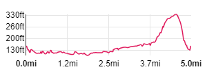
| Route: | the route takes in riverside paths, following the Lune Valley Ramble before leading away from the river along farm tracks, some short stretches of road and through open fields. Parts of the path were very muddy and wet - indeed one section of the river bank path was very steep and slippery and a short stretch of woodland path was like a stream! But it was January and there had been a lot of rain during the previous few days. | ||
| Links to Route Files: | Ordnance Survey OS Maps online
(may only available to OSMaps subscribers) or .gpx
(exported from OS Maps app on Android device - can be imported into many devices).
|
||
| More info: |
|
| |
| Refreshments: | Lots of choice in Kirkby Lonsdale - before setting out on the walk, we enjoyed coffee sat by the fire at the Crossing Point Café. |

|
As it wasn't a weekend, we parked east of the river by Devil's Bridge … |

|
… and then walked across - the picture is looking upstream from Devil's Bridge (built in the 12th or 13th centuries and now a scheduled ancient monument). |

|
At the far side of the bridge cross the field following the direction of the finger post staying closer to the river. |

|
Leave the field close to the newer bridge (which carries the A65 across the river). Walk up to and cross the road.
A rather sorry looking finger post, indicates the way (Lune Valley Ramble, Arkholme 4˝ m) - it could be that only the upright post
will remain by the end of winter!
Walk through the riverside meadow … |

|
… through this stile to follow the direction of the river through the next two fields. |

|
Towards the end of the second field you will see the Haweswater aqueduct cross the Lune (this carries drinking water from the Lake District to Manchester, with the flow entirely by gravity - more information here). Walk up the embankment by the pipeline … |

|
… and cross the stile by the gate pictured. In the next field walk alongside a post and wire fence to … |

|
… what was a very muddy corner on the day we walked. Climb the stile and follow the path between a wooden fence on the right and low trees/bushes on the left. A nother stile leads to the river bank. To start off with there's plenty of room … |

|
… but the bank becomes steeper and the path narrower before reaching a stile over a leaning wooden fence. Once over the stile, the path leads up to … |

|
… follow the edge of the field pictured. There are three more stiles before … |

|
… passing the wooden shelter in the photograph. Almost immediately after passing the shelter … |

|
… bear right over a cattle grid. Follow the track away from the river and … |

|
... over another cattle grid. Continue up the lane until … |

|
…it forks and meets the road. Bear right along the road through the village. Unfortunately there are no longer any places of refreshment in the village - the Dragon's Head having closed a couple of years ago. The village website says that it has been acquired by new owners - however there was still an estate agents board inviting, "All Enquiries" when we passed. |

|
Follow the main road round to the right and continue along the road for about half a mile … |

|
… and then follow the footpath sign on the right. This takes you across a field, down to step over a stream and then to … |

|
… to this stile. Go through the stile and continue north across the next field. |

|
A stone stile leads onto a farm track - turn left and then left again onto the road.. |

|
About 30 metres along the road, where it bends to the left, follow the track on the right. |

|
Where the track divides, fork left walking towards a large barn on your left. |

|
By the end of the barn go through the gates and ... |

|
… carry on straight ahead. Go through the gate pictured, following the path … |

|
... through a wooded area. |

|
It became difficult to distinguish the path from the stream - a helpful yellow arrow on a tree stump pointed out the correct route. |

|
The path became drier and lead … |

|
… to a narrow farm road. |

|
Go through the kissing gate directly across the farm road, following the sign for Devil's Bridge. |

|
Continue ahead to pass through the gateway in the stone wall, and then turn right … |

|
… to follow the wall through a couple of kissing gates. |

|
Walk down to … |

|
… a metal kissing gate. Cross the road and follow the narrow path directly ahead, between houses. Go through two more metal kissing gates, the 2nd of which … |

|
… brings you out onto the A65. Cross the road, pass through the kissing gate ahead and walk back to Devil's Bridge. |
Other walks near here:
All text and images ©Graham Dean, February, 2019.
Back to:


