| Maps:
|
Sheet 287 West Pennine Moors
|
View Jumbles Country Park in a larger map
|
| Start: |
SD735139 Jumbles Country Park car park (pay and display).
|
|
Route:
| Click here to view the route superimposed on GoogleEarth
(GoogleEarth must be installed on your computer
in order to view - click here to download GoogleEarth).
This walk follows clear footpaths and tracks, mainly along the waymarked Witton Weavers Way. It leads from the Bradshaw Valley,
past a Tudor hall, over moorland, then drops down to the valley again, passing reservoirs and the remains of an earlier
industrial age.
|
|
More info:
|
Jumbles Country Park information from United Utilities;
Turton Tower from CottonTown website.
|
|
Refreshments: |
For details of opening times and refreshments available from the Jumbles Car Park and from Turton Tower, follow links above;
The Strawberry Duck, Entwistle
The Black Bull, Turton
|
|
|
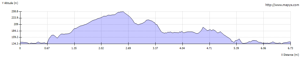
| Route profile: |
|

|
Leave the car park by crossing the access road and walking past the disabled parking spaces and the café.
|
|

|
Continue following the clear path along the eastern side of Jumbles Reservoir until the reservoir narrows and you come to …
|

|
… the bridge which crosses to the western shore.
|

|
Cross the bridge and walk up the stepped path opposite.
|

|
This path leads through a small area of woodland, before emerging through a kissing gate into an area of rough pasture.
|

|
Follow the path until it meets …
|

|
… a road. Note the, now rare, example of a WW2 pillbox on the left.
Turn left to walk along the road for a little more than 200 yards.
|

|
When you reach the driveway into Turton Tower, turn right to follow the drive. Walk past the car park …
|

|
… and the gateway to this Grade 1 Listed Tudor building. Continue along the track to cross …
|

|
… this unique (Grade 2 Listed) bridge over the railway. This is the more ornate of two bridges built by the Blackburn,
Darwen and Bolton Railway Company to comply with the wishes of the then owner of Turton Tower.
|

|
After crossing the bridge, continue along the track until it divides. Take the right hand fork.
|

|
The clear track continues for about 1Ľ miles.
|

|
Just before the track meets Greens Arms Road, take the footpath on the right. This emerges onto the road.
Cross the road and follow the bridleway opposite …
|

|
… which leads downhill. Cross the car park access road and follow the path down to the edge of the car park.
|

|
Take the path to the right in front of stone wall, and then almost immediately turn left down steps to lower car park.
When you meet the road, turn left again, to cross Turton and Entwistle reservoir embankment.
|

|
Walk up the road from the reservoir to pass cottages on your right.
|

|
We stopped at the Strawberry Duck for some refreshment, before following the road across the railway bridge.
|

|
Look out for the fingerpost on the left, go through the gate and walk down the hill.
|

|
Cross two footbridges over streams which feed into Wayoh Reservoir and then turn right.
|

|
Follow the reservoir bank to emerge on to the road. Cross and go through the gate opposite.
|

|
The path continues alongside the reservoir …
|

|
… providing views across the valley …
|

|
… before emerging in Edgworth next to the Black Bull. Turn right to follow Bolton Road down the hill.
|

|
Cross the road and turn left into Birches Road. Follow the road as it bends first to the left and then to the right.
|

|
After passing the last of the houses on the right, the track climbs uphill. Shortly after passing through a wooden gate look out for the small footpath marker in trees on the right.
Take the path indicated by this marker. It leads down through woodland …
|

|
… to emerge by the side of Bradshaw Brook.
|

|
Continue to follow the path alongside the stream …
|

|
… where there are traces of channels for former water powered workings alongside the stream.
Although the water hasn't been used as a power source for industry since the 1800s, the reservoir
was constructed in the 1960s to ensure a steady flow of water for other industrial uses in the Croal-Irwell rivers.
|

|
The brook widens as it enters the reservoir. When you meet the path which crosses the bridge, re-trace your steps
alongside the reservoir to return to the car park.
|


