|
Enter the wood by the gate at the far end of the car park. After about 270 metres …
|

|
… you come to a junction of paths. Turn right to follow the sign towards Waterslack. After less than 200 metres …
|

|
… the path divides. Take the right hand fork which leads out of the woods by a stile next to a wooden gate.
|

|
Cross farm road and head along the narrow path pictured. A squeeze stile leads onto another farm road …
|

|
… go straight across this. After a short distance climb a stone stile …
|

|
… to cross the railway track. Climb another stone stile and turn left.
|

|
Follow the narrow road for over 500 metres, when the road turns to the left …
|

|
… leading to a gated level crossing. Climb the stile alongside the gate and walk across the track.
Climb the stile pictured then follow the path to the right,
signed towards Arnside Tower.
|

|
The path takes you along the edge of Middlebarrow Wood - paths on the Dallam Estate are always well waymarked.
|

|
The path forks shortly before leaving the wood - take the right hand fork in the direction of Blackdyke.
|

|
The long, straight path follows the edge of fields. There's a splendid view of Arnside Tower and Arnside Knott to the left whilst the railway line is on your right. Just about half way along this stretch a gated footbridge takes you over a field drain.
Before leaving this open section the path leads through gates across a farm road - you then pass through a gate into Hagg Wood. Another gate leads out of the wood …
|

|
… into a field used as pasture for horses. Walk ahead to follow the path between the two barns pictured. Climb a stone stile next to a metal gate …
|

|
... to join Black Dyke Road. Turn left and walk along the road into Arnside.
|

|
Just before reaching the station there is a raised footpath on the left - more pleasant than walking on the road itself.
We called for lunch at our favourite coffee stop in Arnside (Moochin About Jazz Café) which is opposite the railway station.
Follow Station Road as it bends round to the left and becomes The Promenade.
|

|
Walk along the edge of the beach, or along the pavement - if you choose the beach,
you'll probably need to join the promenade, rather than walk around the pier.
|

|
If you haven't visited Arnside before, there are attractive galleries and gift shops - as well as plenty of choice for refreshment.
|

|
After the pier, we walked back on the beach - do check tide times and heights before completing this section of the walk -
Arnside is famed for its tidal bore!
There are alternative routes along Red Barns Road and then New Barns Road, or through Grubinns Wood).
|

|
The beach is a mixture of mud, sand, shingle and rocky outcrops, follow the edge of the beach where it curves round to the left …
|

|
… and turn left onto the narrow road - then go through …
|

|
… the metal kissing gate on the right (signed Arnside Knott and Silverdale). Follow the path between wire and post fences …
|

|
... to the gateway pictured, which takes you into Copridding Wood.
|

|
The path leads uphill to another gate - go through this and continue uphill in the same direction.
|

|
Where the path divides, follow the right fork. This leads to a wall, turn left to follow the wall until …
|

|
… this junction of paths. Go through the gate on the right (still signed for Arnside Tower). The path forks again - again take the right fork.
|

|
There are gates across the paths at the next junction. Here go through the gate straight ahead (signed for Arnside Tower).
Follow the wide woodland path through another wooden gate …
|

|
… before the path descends to meet a minor road. Go across the road and long the farm road opposite (signed as Footpath to Silverdale).
|

|
Just before reaching the farm buildings, go through the gate on the right - the footpath sign reads Cove Road and Elmslack.
In summer months the farm serves ice cream and other refreshments and there is a small children's play area.
Follow the path …
|

|
… through another gate and into the field which contains Arnside Tower. Unfortunately the building is unsafe, so it's not possible to explore it.
Walk up, passing the medieval Pele tower …
|

|
… to climb the ladder stile pictured.
|

|
This is a view the tower, photographed from the top of the stile, looking back.
|

|
Follow the path between low trees and bushes to a wooden kissing gate which leads …
|

|
… into a caravan site (Holgates Holiday Park). There are marker posts which guide you across this ..
|

|
… to the path pictured. After a short distance …
|

|
… walk through the stile pictured and follow the clear woodland path. The path becomes tarmacked ...
|

|
… where it passes houses at Elmslack. At the junction pictured, the road bears right, but we bear left along the stony path (signed Eaves Wood).
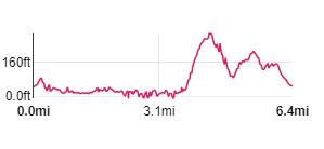
Continue ahead until you reach the path on the right which leads back to the car park.
|
All text and images ©Graham Dean, February, 2019.