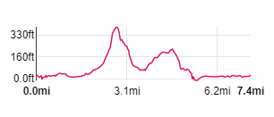
|
From the promenade walk north east, passing the entrance to the car park. The road turns to the south east and becomes Station Road.
Continue along the road, passing the station on your left and Moochin' About Jazz Cafť on your right.
|
|

|
Continue ahead and walk along the raised footpath along the right-hand side of Black Dyke Road.
|

|
Turn left down the track pictured, signed Hazelslack. Take care crossing the railway line and follow the narrow footpath ahead.
At the end of the field the path leads across a footbridge and a wooden gate. Follow the direction a finger posts indicates to Carr Bank Road.
We left this field via an open gateway
(but if the gate is closed, there's smaller wooden gate a few yards to the left). Continuing in the same direction Ö
|

|
Ö takes you to the corner of the next field. A gated stile (next to a large metal gate) brings you to a minor road.
Cross the road and climb a stile in the stone wall in front of you.
Walk towards a limestone outcrop ahead. At the top of this Ö
|

|
Ö go through the gateway pictured. Follow the path going north west towards Hazelslack Tower (one of a number of pele towers in the area).
A stone stile takes you onto a narrow road near to the tower. Turn right Ö
|

|
Ö and walk along the road to the junction pictured. We walked through the open gateway ahead (there's a stile to the left if the gate is closed).
The finger post by the stile says Limestone Link: Beetham via Fairy Steps.
The path runs down the right-hand side of the field, crosses a stone stile and then another. At the end of the second field a wooden gate leads into Ö
|

|
... Underlaid Wood. The right of way through the woods is way-marked at intervals (as shown in the photograph).
|

|
Carry on in the same direction until you reach the rocky outcrop pictured. Climb the steps through the limestone outcrop.
Continue to follow the path through the woods, now heading north east until Ö
|

|
Ö you come to a steeper limestone cliff on your left. This is the foot of the fabled Fairy Steps -
legend has it that if you climb the steps without touching the sides, the fairies will grant you a wish!
Opposite the bottom of the steps, an information board shows an alternative permissive path for those who don't want to venture up the narrow gap.
|

|
At the top, turn left to admire the view across the gap in the rocks to Arnside Knot and the Kent estuary.
The path continues north west between post and wire fences. Again there are posts with way-markers to indicate the right of way Ö
|

|
Ö at a junction of paths, the beehive shaped structure on the right has a disc with way-maker on top.
Continue ahead following the direction indicated for Beetham.
Keep following the waymarker posts along the track for about 300 yards from this marker Ö
|

|
Ö and look out for the taller waymarker post indicating that the right of way leads down a narrower path on the left
(the track ahead is not a public right of way - and will take you in the wrong direction). The narrow path zig-zags Ö
|

|
Ö round a ruined house, through a stone stile before turning to the east and following a stone wall.
|

|
Over the wall you can see the nearest houses in Beetham. I can't remember if it's a stile or a gate that leads through into the field.
Once in the field, follow the clear path (shown in photograph) and then Ö
|

|
Ö a stile by a wooden gate leads onto Church Street in Beetham.
|

|
The road passes between the church and the Post Office/tea room. At the corner, by the Wheatsheaf, turn left Ö
|

|
Ö to follow the road for a short distance. Where the road bears to the right, turn left Ö
|

|
Ö along Mill Lane - which leads (unsurprisingly) to Heron Corn Mill.
|

|
Opposite the corn mill entrance, follow the footpath on your left. After just less than ľ mile Ö
|

|
Ö you emerge on a narrow road. Turn right, then turn left at the next road junction to walk along the road signposted for Storth and Arnside.
|

|
Look out for the disused lime kiln and information board on your left.
|

|
About 800 yards from the last road junction you will see the gateway/stile on you right.
There are two paths signposted - take the one to the left, signed for Storth.
|

|
It isn't always easy to see the path on the ground (due to the carpet of fallen leaves).
However, there are frequent small wooden marker posts.
|

|
After about 600 yards, there is a stone stile on your right. Go through the stile and follow the narrow path ...
|

|
Ö to another stone stile which brings you out onto a narrow road. Turn left and then almost immediately turn right onto Ö
|

|
Ö Yans Lane. Follow the road through the village, passing the Post Office on your left.
|

|
Where roads meet, go straight ahead, between war memorial on left and phone box (pictured) on right. A bridge takes you over the disused railway and then leads you to a road running alongside the estuary.
Cross the road Ö
|

|
Ö and go through the gate pictured. Follow the path between the road and the river (NOTE, at very high tides the path may be submerged).
|

|
Bear right to join the disused railway track and follow this to Ö
|

|
Ö Arnside railway station. Cross the footbridge, leave the station and follow the road back to the start (or wait for your train).
|
All text and images ©Graham Dean, October, 2018.